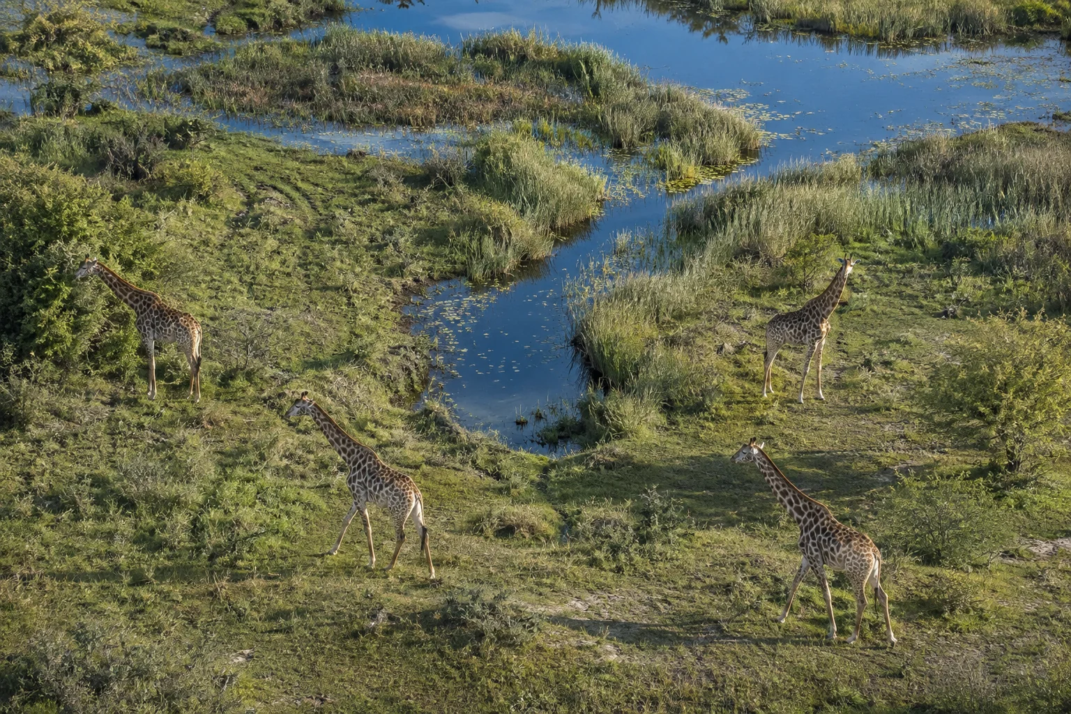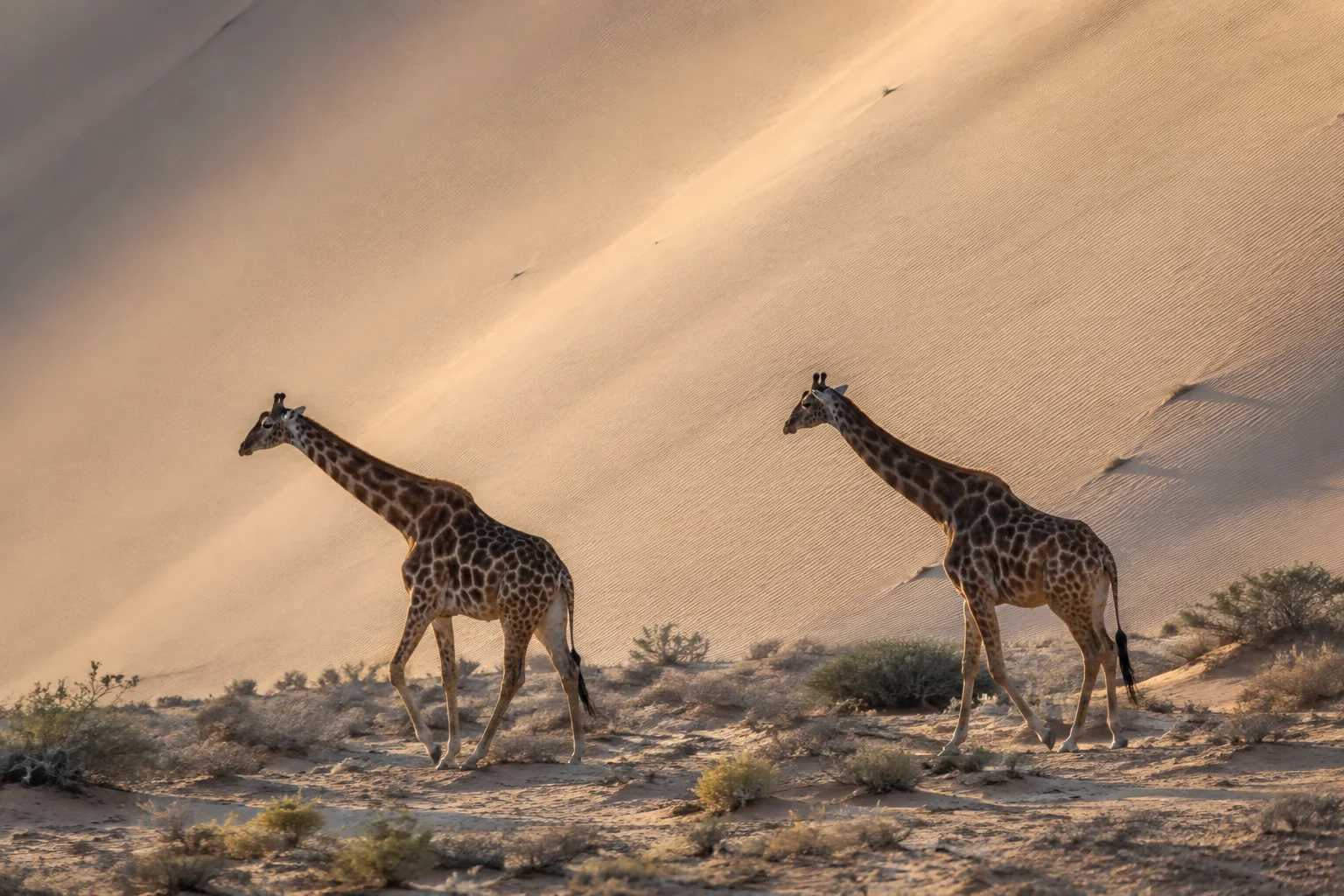
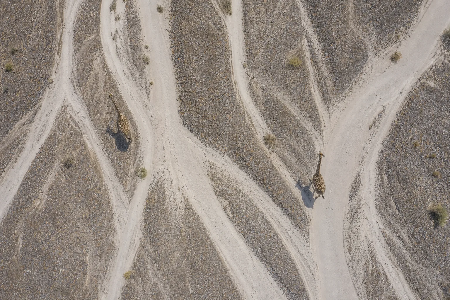
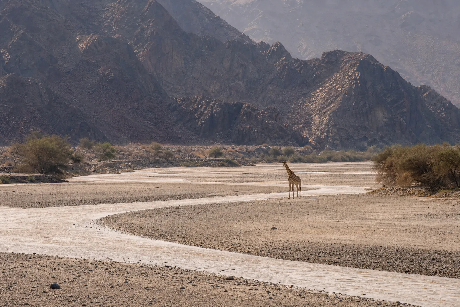
Picture a giraffe walking along a pale riverbed, with little green vegetation visible beyond its banks. It can look like an animal stranded in the wrong landscape. Yet desert environments in northwest Namibia are genuine giraffe habitat. The surprise reveals the problem with a single savanna picture: to understand where giraffes live, we need to look for usable resources, not just a familiar backdrop.
Where do giraffes live in the wild?
Giraffes are native to sub-Saharan Africa. Their habitats include savannas, open woodlands, scrub and some extremely dry landscapes. They do not occupy all of Africa, and a country containing giraffes is not a country covered uniformly by giraffe habitat.
The Smithsonian's giraffe conservation programme illustrates this variety through contrasting study environments:
| Regional example | Habitat described | What to notice |
|---|---|---|
| Northwest Namibia | Very dry desert landscapes | Dryness alone does not exclude giraffes |
| Northwest Uganda | Savanna with more moisture | Not every giraffe landscape is equally arid |
| Northern Kenya | Semi-arid scrub | Habitat need not resemble tall, closed woodland |
| Niger's Sahel | Dry scrub landscapes | Giraffe geography extends beyond southern and eastern Africa |
These examples are an introduction, not a complete distribution map or a list of guaranteed sightings. For the biological names, start with the four giraffe species. For the resources an animal actually eats, see what giraffes eat. A green patch on a map is not a diet description.
Where are the four giraffe species found?
The IUCN specialist-group announcement of August 2025 recognises northern, reticulated, Masai and southern giraffes. The names help organise geography, but they are not four tidy quarters of the continent.
As a broad orientation, northern giraffes have scattered populations across parts of West, Central and East Africa. Reticulated giraffes are strongly associated with northern Kenya; Masai giraffes with southern Kenya, Tanzania and Zambia's Luangwa Valley; southern giraffes with southern Africa, including Namibia, Botswana and South Africa.
These are regional examples, not an exhaustive current-country inventory. The 2019 geographic-range synthesis describes these patterns and important uncertainties, including possible reticulated populations in Ethiopia and Somalia. A historical map cannot certify today's occupancy at every site.
Why a country name is not enough
Kenya illustrates the problem with identifying an animal from its country alone: more than one giraffe species occurs there. A photograph's location can inform identification, but managed movements and local population history also matter. Do not turn a broad geographic label into a definitive species test.
The Kenya country guide puts its three giraffe groups, broad ranges and dated national census entries in one source map.
Likewise, a species name is not its extinction-risk category. Classification, distribution and abundance answer different questions. The population-estimate guide explains why a count needs a date and a clearly defined group.
Savanna, woodland, desert: how can all be giraffe habitat?
“Savanna” describes a landscape, not one fixed recipe of grass, trees and rainfall. “Woodland” is not synonymous with dense tropical rainforest, and a desert landscape need not be a continuous surface without vegetation. These distinctions matter when looking at photographs or reading habitat labels.
The Namibia example
The Smithsonian examples above make the desert point directly. Calling a place desert does not tell you where its usable plants are distributed. A broad dry landscape can contain places an animal uses much more than the surrounding ground.
That is a useful way to read the riverbed illustrations here: ask where browse could occur and what observations would establish actual use. Do not infer a real route, a drought event or a conservation success from an attractive image.
What about jungles and rainforests?
Dense equatorial rainforest is not the usual habitat described for giraffes. Their close living relative, the okapi, does inhabit rainforest in northeastern Democratic Republic of the Congo, as explained in San Diego Zoo's okapi account.
This distinction is more useful than treating every place with trees as jungle. It also avoids confusing giraffes with another member of their family. When a source says “forest,” check whether it means open woodland, river-associated vegetation or dense rainforest before deciding that two accounts disagree.
What makes a landscape usable?
Habitat is not simply scenery around an animal. Food availability and access to resources help explain where it can spend time. Those resources can change even when the broad landscape label stays the same.
Leaves, shrubs and moisture
San Diego Zoo's giraffe account describes browsing on woody vegetation and obtaining water from leaves. That helps explain why grass cover and open water are not sufficient indicators of giraffe habitat quality.
It does not mean giraffes never drink or can live without water. Water contained in food still counts as water. Nor does the presence of a single tree establish that a whole population can persist there: the quantity, accessibility and persistence of food remain separate questions.
For a reader comparing two photographs, start with what is visible. Are there woody plants? Can you distinguish leaves from bare branches? Is the image dated? What remains outside the frame? These questions prevent a landscape impression from becoming a confident diagnosis.
Browsing also changes plants. The ecological-role guide explains why those effects are not always beneficial to every tree. A habitat story should not assume that adding more giraffes automatically improves vegetation.
How much space does a giraffe need?
There is no single area figure in the evidence here that can be applied to every giraffe. A home range describes an individual's use of space over a defined period; a species range describes geographic distribution at a different scale.
A 2023 pan-African movement study analysed tracking records for 148 range-resident giraffes across all four species. Space use varied with environmental resources and human disturbance. Greater human disturbance was associated with smaller ranges and reduced movement overall.
The analysis does not establish that every small range is unhealthy, or that enlarging an enclosure to a research average satisfies an animal's needs. Tracking estimates depend on the animal, period and method. They are not husbandry standards.
An everyday analogy helps separate the scales: a person's travel over one month is not a map of every place humans live. Similarly, one giraffe's recorded movements cannot outline the whole species' distribution. Our behaviour guide also distinguishes spatial and social relationships; animals near one another are not necessarily a permanent herd.
How to read a giraffe range map
A coloured area looks authoritative. Before interpreting it, ask what information the colour represents. Is it confirmed presence, possible presence, historical distribution or modelled suitability? Those categories should not be silently combined.
The 2019 synthesis cited above demonstrates the distinction: some additions corrected omitted information rather than recording new expansion. A changed boundary is therefore not automatically a biological change.
A short map-reading exercise
Imagine that a new survey finds giraffes in a valley missing from an older map. The new map includes the valley. What can you conclude?
You can say that documented distribution has changed. You cannot yet say when giraffes arrived, whether their numbers increased, or whether a conservation action caused the difference. Those conclusions require additional evidence. This is a hypothetical exercise, not a report of a newly discovered population.
Use four checks when comparing real maps: publication date, biological group, meaning of the shading, and the observations behind the boundary. Comparing two differently defined layers can produce a dramatic-looking change without a fair like-for-like comparison.
For public learning, broad regional information is usually sufficient. This guide does not publish precise locations of vulnerable animals or tracking coordinates. It is a geographic explanation, not a tool for locating individual giraffes.
Do corridors connect giraffe habitats?
They can be relevant to conservation planning, but a line labelled corridor is not proof that animals use it. Potential connection, observed movement and improved survival are different outcomes.
A 2024 study of the Tsavo–Mkomazi landscape used giraffe observations and environmental information to model habitat suitability and connectivity. It identified important areas beyond a simple division between parks and everything outside them.
The authors explicitly did not quantify the effects of particular infrastructure on movements or giraffe use of railway underpasses. The maps suggest where further investigation is valuable; they do not document every crossing.
That distinction gives a practical question for any corridor proposal: what was predicted, what was observed, and what changed after the intervention? The giraffe-threats guide puts habitat fragmentation alongside other pressures without treating one response as a universal solution. The habitat-loss and fragmentation research collection provides a route into the underlying literature.
What can visitors and families observe?
At a zoo, an animal's location answers where it is housed, not where its lineage is native. Use signs to identify the reported species and origin; do not mistake the presence of giraffes outside Africa for evidence of a native population there. Our Warsaw giraffe guide distinguishes visitor information from biological range.
For a simple activity, make two columns: “what I saw” and “what I still need to know.” Put visible feeding, vegetation and movement in the first. Put the season, plant identity, total home range and long-term habitat quality in the second unless there is evidence for them.
The same method works with a documentary, provided you notice cuts and changes of location. Do not treat an edited sequence as one continuous journey. The kids guide offers a printable evidence-literacy activity for continuing this kind of careful observation.
What to remember
Giraffe habitat is more varied than one savanna image. Start with Africa's regional diversity, then distinguish the species, the resources available and the scale of the claim. A desert label does not exclude giraffes; a green map does not prove suitable habitat everywhere.
Most importantly, separate a map from a movement record and a movement record from a conservation outcome. Each can be useful without claiming to answer all three questions.
Frequently asked questions
Are giraffes native only to Africa? Yes. Their native distribution is in sub-Saharan Africa. Animals housed elsewhere do not make those places part of their native range.
Do giraffes live in deserts? Yes, including desert landscapes in northwest Namibia. That does not mean every part of every desert provides suitable resources.
Do giraffes live in rainforests? Dense equatorial rainforest is not their usual habitat. The closely related okapi is a rainforest animal.
Which country has giraffes? Many African countries do, including Kenya, Tanzania, Uganda, Namibia, Botswana and South Africa. These examples are not a complete country inventory or a guarantee of presence throughout each country.
Does a larger range map mean more giraffes? Not necessarily. Better survey coverage or correction of an omission can enlarge documented range without demonstrating population growth.
Sources
Seven institutional and research references are linked beside their claims. The 2019 distribution synthesis supplies dated regional context and a map-reading example, not a September 2026 census. The movement and connectivity papers answer distinct questions. Species terminology follows the 2025 IUCN specialist-group announcement; no new extinction-risk assessment is inferred.
Reviewed on 6 September 2026.
Sample-count correction, 10 September 2026: the movement study's Results report 148 giraffe trajectories. This replaces 149 from an older author-hosted abstract; the ecological interpretation is unchanged.